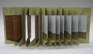
﻿<?xml version="1.0" encoding="utf-8"?>
<?xml-stylesheet type="text/xsl" href="UCFLibEAD.xsl"?>
<!--DOCTYPE ead PUBLIC "+//ISBN 1-931666-00-8//DTD ead.dtd (Encoded Archival Description (EAD) Version 2002)//EN" "C:/ead2002/ead.dtd"-->
<ead relatedencoding="MARC21"> 
  <eadheader audience="internal" findaidstatus="edited-full-draft" id="a0" langencoding="iso639-2b" countryencoding="iso3166-1" repositoryencoding="iso15511" dateencoding="iso8601" scriptencoding="iso15924">
	 
	 <eadid countrycode="us" url="http://library.ucf.edu/SpecialCollections" publicid="//us::FTU//TEXTus::FTU::CFM1995_05.xml//EN" mainagencycode="FTU">CFM1995_05</eadid> 
	 <filedesc> 
		<titlestmt> 
		  <titleproper>Guide to the Thomas and Georgine Mickler Map
			 Collection, 
			 <date normal="1772/1995.">1735-1995.</date></titleproper> 
		  <author>Processed by Jessica Achberger; finding aid prepared by Jessica
			 Achberger.  Additions made by Hadi Sheikhnia.</author> 
		</titlestmt> 
		<publicationstmt> 
		  <publisher id="UCF">University of Central Florida Libraries Special
			 Collections and University Archives. </publisher> 
		  <address> 
			 <addressline>PO Box 162666, </addressline> 
			 <addressline>Orlando, FL 32816-2666, </addressline> 
			 <addressline>Telephone: 407-823-2576,</addressline> 
			 <addressline> E-mail: speccoll@mail.ucf.edu</addressline> 
		  </address> 
		  <date type="Publication" normal="2007">© 2007</date> 
		  <p>University of Central Florida Special Collections and University
			 Archives. All rights reserved.</p> 
		</publicationstmt> 
	 </filedesc> 
	 <profiledesc> 
		<creation>Finding Aid encoded by Jessica Achberger and Hadi Sheikhnia
		  <date normal="2007">2007</date></creation> 
		<langusage>Description is written in <language langcode="eng">English</language></langusage> 
		<descrules>Finding Aid prepared using 
		  <title>Describing Archives: A Content Standard</title></descrules> 
	 </profiledesc> 
  </eadheader> 
  <archdesc level="recordgrp" type="Inventory" id="a19" relatedencoding="MARC">
	 
	 <did id="P2"> 
		<head>Descriptive Summary</head> 
		<unittitle label="Title" encodinganalog="245$a">The Thomas and Georgine
		  Mickler Map Collection 
		  <unitdate label="Dates" type="inclusive" normal="1772/1995" encodinganalog="245$f">1735-1995</unitdate></unittitle> 
		<unitid label="Accession Number" countrycode="us" repositorycode="FTU" encodinganalog="099">CFM1995_05</unitid> 
		<origination label="Creator" encodinganalog="100">These maps were
		  collected by Thomas and Georgine Mickler.</origination> 
		<physdesc label="Extent" encodinganalog="300$a"> <extent>1 Box, 5 Flat
		  Files, </extent> <extent>7.5 Linear feet</extent> </physdesc> 
		<repository label="Repository"> 
		  <corpname>Special Collections and University Archives,</corpname> 
		  <corpname>University of Central Florida Libraries, </corpname> 
		  <address> 
			 <addressline>PO Box 162666, </addressline> 
			 <addressline>Orlando, FL 32816-2666, </addressline> 
			 <addressline>Telephone: 407-823-2576,</addressline> 
			 <addressline> E-mail: speccoll@mail.ucf.edu</addressline> 
		  </address> </repository> 
		<abstract label="Abstract" encodinganalog="520$a">The Thomas and Georgine
		  Mickler Map Collection is a collection of various kinds of maps, including
		  general atlas maps, road maps, topographical land maps, charts and political
		  maps. While the collection mostly consists of maps of Florida, the Southeastern
		  United States and the West Indies/Caribbean, there are also maps of other areas
		  such as Egypt, France and Costa Rica.</abstract> 
		<langmaterial label="Language of Material" encodinganalog="546$a">
		  <language langcode="eng">English, </language> <language langcode="spa">Spanish</language> </langmaterial> 
	 </did> 
	 <acqinfo encodinganalog="541"> 
		<head>Acquisition Information</head> 
		<p>These materials were purchased from Thomas and Georgine Mickler by the
		  University of Central Florida Libraries, Special Collections and University
		  Archives in 1999.</p> 
	 </acqinfo> 
	 <processinfo id="a20" audience="internal"> 
		<head audience="internal">Processing Information</head> 
		<p audience="internal">This collection was processed by individual item.
		  Smaller maps are foldered, and sometimes sleeved, in acid free folders and
		  envelopes, in a half box. Larger maps are held in map drawers, with more
		  delicate maps sleeved in plastic or separated by acid free folders. With the
		  exception of road maps, all maps have been unfolded and laid flat for
		  storage.</p> 
	 </processinfo> 
	 <accessrestrict audience="internal" encodinganalog="506"> 
		<head>Access</head> 
		<p>The entire collection is open for research.</p> 
	 </accessrestrict> 
	 <userestrict encodinganalog="540"> 
		<head>Copyright Statement</head> 
		<p>Unpublished manuscripts are protected by copyright. Permission to
		  publish, quote or reproduce must be secured from the repository and the
		  copyright holder.</p> 
	 </userestrict> 
	 <prefercite> 
		<head>Preferred Citation</head> 
		<p>Thomas and Georgine Mickler Map Collection, Special Collections and
		  University Archives, University of Central Florida, Orlando, Florida.</p> 
	 </prefercite> 
	 <relatedmaterial> 
		<head>Related Material</head> 
		<p>Special Collections and University Archives at the University of
		  Central Florida holds other materials collected by Thomas and Georgine Mickler.
		  Further materials on Florida and the West Indies may be found in the Florida
		  Ephemera and William L. Bryant West Indies Collections. For more information
		  about these collections, please see the finding aids on our website.</p> 
	 </relatedmaterial> 
	 <bioghist id="a2" encodinganalog="545"> 
		<head>Biographical/Historical Note</head> 
		<p>Thomas and Georgine Mickler ran a small publishing company, Mickler
		  House, and a thriving mail-order business, Mickler's Antiquarian Books, out of
		  their Chuluota home for almost 40 years. The Mickler's focused on tracing
		  out-of-print publications about Florida and ultimately collected more than
		  40,000 books and other historical pieces of paper memorabilia that filled their
		  home. Thomas Mickler was a native Floridian but Georgine was born in Chicago.
		  She moved to Orlando in 1961, and they married the following year. Both of them
		  lived until they were 84 years old; Thomas died in 1997 and Georgine died a
		  year later.</p> 
	 </bioghist> 
	 <scopecontent id="a3" encodinganalog="520"> 
		<head> Collection Scope and Content</head> 
		<arrangement> 
		  <p>This collection was arranged by geographic location into four
			 series. Each series was further divided by type of map.</p> 
		</arrangement> 
		<p>The Thomas and Georgine Mickler Map Collection is a collection of
		  various types of maps, including atlas maps, road maps, topographical maps and
		  charts. While most of the maps are of Florida and the areas around it,
		  including the Southeastern United States and the West Indies/Caribbean, there
		  are also maps from other geographic regions around the world.</p> 
		<p>Series I: Florida Maps, 1740-1984 contains maps of the state of
		  Florida arranged by type of map into general atlas maps, road maps,
		  topographical land maps, charts and political maps.</p> 
		<p>Series II: Southeastern United States Maps, 1735-1977 consists of maps
		  of the southeastern portion of the United States, including Georgia, Louisiana,
		  Alabama and South Carolina. This includes general atlas maps, road maps,
		  topographical land maps and political maps.</p> 
		<p>Series III: West Indies/Caribbean Maps, 1816-1995 includes maps of the
		  islands and waterways of the West Indies/Caribbean. This series is divided into
		  general atlas maps, topographical land maps, charts and Air Info current
		  maps.</p> 
		<p>Series IV: Maps of Other Areas, 1760-1818 contains maps of geographic
		  areas outside Florida, the Southeast and the Caribbean. General atlas maps,
		  road maps and topographical land maps cover areas such as Egypt, France and
		  Costa Rica.</p> 
	 </scopecontent> 
	 <controlaccess> 
		<head>Selected Subject and Access Points</head> 
		<p>Similar records may be found by searching under the following index
		  terms.</p> 
		<subject encodinganalog="650" source="local">Florida--Maps.</subject> 
		<subject encodinganalog="650" source="local">Florida--Maps,
		  Topographic.</subject> 
		<subject encodinganalog="650" source="lcsh">Roads Maps.</subject> 
		<subject encodinganalog="650" source="lcsh">Topographic maps.</subject> 
		<subject encodinganalog="650" source="lcsh">World maps.</subject> 
		<subject encodinganalog="650" source="lcsh">Nautical Charts.</subject> 
		<geogname encodinganalog="651" source="lcsh">Florida.</geogname> 
		<geogname encodinganalog="651" source="local">Caribbean.</geogname> 
	 </controlaccess> 
	 <dsc type="combined" id="a23"> 
		<head>Contents List</head> 
		<c01 level="series" id="seriesI"> 
		  <did> 
			 <unittitle>Series I: Florida Maps. </unittitle> 
			 <unitdate normal="">1740-1984. </unitdate> 
			 <physdesc><extent>4 Linear feet</extent> </physdesc> 
		  </did> 
		  <scopecontent> 
			 <p>Series I consists of various maps of Florida, divided into
				subseries. The first subseries contains general atlas maps from textual
				sources, such as the 
			 <title render="italic">Atlas of the World</title>. The series also
			 includes a subseries for road maps, mostly from the 1970s and 1980s produced by
			 the Champion Map Corporation. Many of the charts, or maps of the waterways
			 around Florida, were created by the U.S. Coastal Survey and topographical land
			 maps include maps created by the U.S. Department of the Interior regarding
			 mineral deposits and reports of the Surveyor General. The final subseries,
			 political maps, are maps of Florida showing distinctions such as county lines
			 and postal regions. (Administrator’s note: the items in his series are numbered by their order in the finding aid.)</p> 
		  </scopecontent> 
		  <thead audience="external"> 
			 <row> 
				<entry>Box</entry> 
				<entry>Flat-File</entry> 
			 </row> 
		  </thead> 
		  <c02 level="subseries"> 
			 <did> 
				<unittitle>General Atlas Maps.</unittitle> 
				<unitdate>1740-1927.</unitdate> 
			 </did> 
			 <c03 level="item"> 
				<did> 
				  <container type="Flat-File">Flat File 2</container> 
				  <unittitle>Map of Part of West Florida. Item 1 </unittitle> 
				  <unitdate>1772.</unitdate> 
				  <physdesc> <dimensions>12.25 in x 26 in</dimensions> </physdesc> 
				</did> 
				<scopecontent> 
				  <p>From Pensacola to the mouth of the Iverville River; plan for a
					 new settlement of the Mississippi.</p> 
				</scopecontent> 
			 </c03> 
			 <c03 level="item"> 
				<did> 
				  <container type="Flat-File">Flat File 2</container> 
				  <unittitle>Colton's Florida. Item 2 <imprint> 
					 <publisher>J.H. Cotton, </publisher> 
					 <geogname role="publication place">New York.</geogname>
					 </imprint> </unittitle> 
				  <unitdate>1855.</unitdate> 
				  <physdesc> <dimensions>17.5 in x 22.5 in</dimensions> </physdesc>
				  
				</did> 
			 </c03> 
			 <c03 level="item"> 
				<did> 
				  <container type="Flat-File">Flat File 2</container> 
				  <unittitle>Johnson's Florida. Item 3 <imprint> 
					 <publisher>A.J. Johnson, </publisher> 
					 <geogname role="publication place">New York.</geogname>
					 </imprint> </unittitle> 
				  <unitdate>1863.</unitdate> 
				  <physdesc> <dimensions>12.25 in x 16.25 in.</dimensions>
					 </physdesc> 
				</did> 
			 </c03> 
			 <c03 level="item"> 
				<did> 
				  <container type="Flat-File">Flat File 2</container> 
				  <unittitle>Johnson's Florida. Item 4 <imprint> 
					 <publisher>Johnson and Browning. </publisher> </imprint>
					 </unittitle> 
				  <unitdate>1862.</unitdate> 
				  <physdesc> <dimensions>13.75 in x 17.75 in.</dimensions> 3
					 copies. </physdesc> 
				</did> 
			 </c03> 
			 <c03 level="item"> 
				<did> 
				  <container type="Flat-File">Flat File 2</container> 
				  <unittitle>Johnson's Florida. Item 5 <imprint> 
					 <publisher>Johnson and Ward. </publisher> </imprint>
					 </unittitle> 
				  <unitdate>1862.</unitdate> 
				  <physdesc> <dimensions>13.75 in x 17.75 in.</dimensions> 2 copies.
					 </physdesc> 
				</did> 
			 </c03> 
			 <c03 level="item"> 
				<did> 
				  <container type="Flat-File">Flat File 2</container> 
				  <unittitle>Florida. Item 6</unittitle> 
				  <unitdate>1923.</unitdate> 
				  <physdesc> <dimensions>9.25 in x 6.5 in.</dimensions> </physdesc>
				  
				</did> 
				<scopecontent> 
				  <p>Pg. 80 of the 
				  <title render="italic">Atlas of the World.</title></p> 
				</scopecontent> 
			 </c03> 
			 <c03 level="item"> 
				<did> 
				  <container type="Flat-File">Flat File 2</container> 
				  <unittitle>Florida. Item 7</unittitle> 
				  <unitdate>1927.</unitdate> 
				  <physdesc> <dimensions>9.25 in x 6.5 in.</dimensions> </physdesc>
				  
				</did> 
				<scopecontent> 
				  <p>Pg. 96 of the 
				  <title render="italic">Literary Digest.</title></p> 
				</scopecontent> 
			 </c03> 
			 <c03 level="item"> 
				<did> 
				  <container type="Flat-File">Flat File 2</container> 
				  <unittitle>Florida. Item 8 <imprint> 
					 <publisher>George F. Cram, Engraver and Publishers,
						</publisher> 
					 <geogname role="publication place">Chicago,
						Illinois.</geogname> </imprint> </unittitle> 
				  <unitdate>1883.</unitdate> 
				  <physdesc> <dimensions>13.75 in x 10.5 in.</dimensions>
					 </physdesc> 
				</did> 
			 </c03> 
			 <c03 level="item"> 
				<did> 
				  <container type="Flat-File">Flat File 2</container> 
				  <unittitle>Map of Florida. Item 9 <imprint> 
					 <publisher>Kenyon Company Map Makers, </publisher> 
					 <geogname role="publication place">Des Moines, Iowa.</geogname>
					 </imprint> </unittitle> 
				  <unitdate>1912.</unitdate> 
				  <physdesc> <dimensions>22.25 in x 16.25 in.</dimensions>
					 </physdesc> 
				</did> 
			 </c03> 
			 <c03 level="item"> 
				<did> 
				  <container type="Flat-File">Flat File 2</container> 
				  <unittitle>Florida. Item 10</unittitle> 
				  <unitdate>circa 1902.</unitdate> 
				  <physdesc> <dimensions>14.75 in x 11.75 in.</dimensions> 2
					 copies. </physdesc> 
				</did> 
				<scopecontent> 
				  <p>Pg. 51 of a book.</p> 
				</scopecontent> 
			 </c03> 
			 <c03 level="item"> 
				<did> 
				  <container type="Flat-File">Flat File 2</container> 
				  <unittitle>Untitled Map of Florida. Item 11</unittitle> 
				  <unitdate>undated.</unitdate> 
				  <physdesc> <dimensions>8.75 in x 11.5 in.</dimensions> 3 copies.
					 </physdesc> 
				</did> 
				<scopecontent> 
				  <p>Map surrounded by text.</p> 
				</scopecontent> 
			 </c03> 
			 <c03 level="item"> 
				<did> 
				  <container type="Flat-File">Flat File 2</container> 
				  <unittitle>Florida. Item 12</unittitle> 
				  <unitdate>undated.</unitdate> 
				  <physdesc> <dimensions>13.5 in x 10.5 in.</dimensions>
					 </physdesc> 
				</did> 
				<scopecontent> 
				  <p>Pg. 18 out of a book with some text.</p> 
				</scopecontent> 
			 </c03> 
			 <c03 level="item"> 
				<did> 
				  <container type="Flat-File">Flat File 2</container> 
				  <unittitle>Florida. Item 13</unittitle> 
				  <unitdate>undated.</unitdate> 
				  <physdesc> <dimensions>10.25 in x 13.75 in.</dimensions> 3
					 copies. </physdesc> 
				</did> 
				<scopecontent> 
				  <p>Pg. 23 from 
				  <title render="italic">Atlas of the World.</title></p> 
				</scopecontent> 
			 </c03> 
			 <c03 level="item"> 
				<did> 
				  <container type="Flat-File">Flat File 2</container> 
				  <unittitle>View of the Town and Castle of St. Augustine, and the
					 English Camp. Item 14<imprint> 
					 <publisher>Thomas Silver. </publisher> </imprint> </unittitle> 
				  <unitdate>20 June 1740.</unitdate> 
				  <physdesc> <dimensions>12.5 in x 8.5 in.</dimensions> </physdesc>
				  
				</did> 
			 </c03> 
			 <c03 level="item"> 
				<did> 
				  <container type="Flat-File">Flat File 2</container> 
				  <unittitle>Florida. Item 15<imprint> 
					 <publisher>Phillips and Hunt, </publisher> 
					 <geogname role="publication place">New York, New
						York.</geogname> </imprint> </unittitle> 
				  <unitdate>undated.</unitdate> 
				  <physdesc> <dimensions>13.25 in x 11.75 in.</dimensions>
					 </physdesc> 
				</did> 
			 </c03> 
			 <c03 level="item"> 
				<did> 
				  <container type="Flat-File">Flat File 2</container> 
				  <unittitle>Map of Florida. Item 16 <imprint> 
					 <publisher>Thomas, Cooperwaith and Co., </publisher> 
					 <geogname role="publication place">Pennsylvania.</geogname>
					 </imprint> </unittitle> 
				  <unitdate>1850.</unitdate> 
				  <physdesc> <dimensions>17 in x 12.25 in.</dimensions> </physdesc>
				  
				</did> 
			 </c03> 
			 <c03 level="item"> 
				<did> 
				  <container type="Flat-File">Flat File 2</container> 
				  <unittitle>Johnson's Florida. Item 17 <imprint> 
					 <publisher>A.J. Johnson, </publisher> 
					 <geogname role="publication place">New York.</geogname>
					 </imprint> </unittitle> 
				  <unitdate>undated.</unitdate> 
				  <physdesc> <dimensions>14 in x 17.5 in.</dimensions> 3 copies. </physdesc> 
				</did> 
			 </c03> 
			 <c03 level="item"> 
				<did> 
				  <container type="Flat-File">Flat File 2</container> 
				  <unittitle>Florida. Item 18</unittitle> 
				  <unitdate>undated.</unitdate> 
				  <physdesc> <dimensions>12.5 in x 10 in.</dimensions> 6 copies.
					 </physdesc> 
				</did> 
				<scopecontent> 
				  <p>Reproduction of 1833 Bradford Map.</p> 
				</scopecontent> 
			 </c03> 
			 <c03 level="item"> 
				<did> 
				  <container type="Flat-File">Flat File 2</container> 
				  <unittitle>Florida. Item 19<imprint> 
					 <publisher>J.H. Colton and Co., </publisher> 
					 <geogname role="publication place">New York.</geogname>
					 </imprint> </unittitle> 
				  <unitdate>undated.</unitdate> 
				  <physdesc> <dimensions>19 in x 25 in.</dimensions> 5 copies.
					 </physdesc> 
				</did> 
				<scopecontent> 
				  <p>Reproduction of University of Miami publication.</p> 
				</scopecontent> 
			 </c03> 
			 <c03 level="item"> 
				<did> 
				  <container type="Flat-File">Flat File 2</container> 
				  <unittitle>Untitled Map of Florida. Item 20</unittitle> 
				  <unitdate>undated.</unitdate> 
				  <physdesc> <dimensions>19 in x 11.5 in.</dimensions> </physdesc> 
				</did> 
			 </c03> 
			 <c03 level="item"> 
				<did> 
				  <container type="Flat-File">Flat File 2</container> 
				  <unittitle>Florida. Item 21</unittitle> 
				  <unitdate>undated.</unitdate> 
				  <physdesc> <dimensions>13.5 in x 10.75 in.</dimensions> 2 copies.
					 </physdesc> 
				</did> 
				<scopecontent> 
				  <p>Pg. 60 of a book.</p> 
				</scopecontent> 
			 </c03> 
			 <c03 level="item"> 
				<did> 
				  <container type="Flat-File">Flat File 2</container> 
				  <unittitle>Geographical, Statistical and Historical Map of
					 Florida. Item 22</unittitle> 
				  <unitdate>1822.</unitdate> 
				  <physdesc> <dimensions>17.5 in x 22.5 in.</dimensions> 25 copies.
					 </physdesc> 
				</did> 
				<scopecontent> 
				  <p>Facsimile of map from 
				  <title render="italic">Carey and Lea Atlas</title>.</p> 
				</scopecontent> 
			 </c03> 
			 <c03 level="item"> 
				<did> 
				  <container type="Flat-File">Flat File 2</container> 
				  <unittitle>Map of the State of Florida. Item 23 <imprint> 
					 <publisher>I.T. Hinton and Simpkin and Marshall. </publisher>
					 </imprint> </unittitle> 
				  <unitdate>1832.</unitdate> 
				  <physdesc> <dimensions>8.5 in x 10.75 in.</dimensions> 2 copies.
					 </physdesc> 
				</did> 
				<scopecontent> 
				  <p>Engraved and printed by Sears and Co., London.</p> 
				</scopecontent> 
			 </c03> 
			 <c03 level="item"> 
				<did> 
				  <container type="Flat-File">Flat File 2</container> 
				  <unittitle>Map of Florida. Item 24 <imprint> 
					 <publisher>J. Lee Williams. </publisher> </imprint>
					 </unittitle> 
				  <unitdate>1837.</unitdate> 
				  <physdesc> <dimensions>27 in x 17 in.</dimensions> </physdesc> 
				</did> 
				<scopecontent> 
				  <p>Photocopy. of original</p> 
				</scopecontent> 
			 </c03> 
			 <c03 level="item"> 
				<did> 
				  <container type="Flat-File">Flat File 2</container> 
				  <unittitle>Map of Florida. Item 25<imprint> 
					 <publisher>Mast, Crowell and Kirkpatrick, </publisher>
					 </imprint> </unittitle> 
				  <unitdate>undated.</unitdate> 
				  <physdesc> <dimensions>13.5 in x 11 in.</dimensions> 4 copies.
					 </physdesc> 
				</did> 
				<scopecontent> 
				  <p>Pg. 33 of a book.</p> 
				</scopecontent> 
			 </c03> 
			 <c03 level="item"> 
				<did> 
				  <container type="Flat-File">Flat File 2</container> 
				  <unittitle>Rand McNally and Co.'s Map of Florida. Item 26<imprint> 
					 <publisher>Rand McNally and Co. </publisher> </imprint>
					 </unittitle> 
				  <unitdate>1888.</unitdate> 
				  <physdesc> <dimensions>19 in x 12.25 in.</dimensions> 2 copies. </physdesc>
				  
				</did> 
				<scopecontent> 
				  <p>Damaged.</p> 
				</scopecontent> 
			 </c03> 
			 <c03 level="item"> 
				<did> 
				  <container type="Flat-File">Flat File 2</container> 
				  <unittitle>Florida. Item 27</unittitle> 
				  <unitdate>undated.</unitdate> 
				  <physdesc> <dimensions>11.25 in x 14 in.</dimensions> 2 copies.
					 </physdesc> 
				</did> 
				<scopecontent> 
				  <p>Pg. 31 of the 
				  <title render="italic">Atlas of the World</title>.</p> 
				</scopecontent> 
			 </c03> 
			 <c03 level="item"> 
				<did> 
				  <container type="Flat-File">Flat File 2</container> 
				  <unittitle>Florida. Item 28</unittitle> 
				  <unitdate>1895.</unitdate> 
				  <physdesc> <dimensions>8.25 in x 11.125 in.</dimensions>
					 </physdesc> 
				</did> 
				<scopecontent> 
				  <p>Pg. 736 of a book.</p> 
				</scopecontent> 
			 </c03> 
			 <c03 level="item"> 
				<did> 
				  <container type="Flat-File">Flat File 2</container> 
				  <unittitle>Florida. Item 29</unittitle> 
				  <unitdate>circa 1909.</unitdate> 
				  <physdesc> <dimensions>13.5 in x 11 in.</dimensions> </physdesc> 
				</did> 
			 </c03> 
			 <c03 level="item"> 
				<did> 
				  <container type="Flat-File">Flat File 2</container> 
				  <unittitle> Part of the Providence of East Florida. Item 30<imprint> 
					 <publisher>B. Romans. </publisher> </imprint> </unittitle> 
				  <unitdate>1774.</unitdate> 
				  <physdesc> <dimensions>41.5 in x 49.5 in.</dimensions> 2 copies.
					 </physdesc> 
				</did> 
				<scopecontent> 
				  <p>Photocopy. in two part of 1774 original.</p> 
				</scopecontent> 
			 </c03> 
			 <c03 level="item"> 
				<did> 
				  <container type="Flat-File">Flat File 2</container> 
				  <unittitle>Map of Florida. Item 31<imprint> 
					 <publisher>J. Lee Williams, </publisher> </imprint>
					 </unittitle> 
				  <unitdate>1837.</unitdate> 
				  <physdesc> <dimensions>41 in x 30 in.</dimensions> </physdesc> 
				</did> 
				<scopecontent> 
				  <p>Photocopy.</p> 
				</scopecontent> 
			 </c03> 
			 <c03 level="item"> 
				<did> 
				  <container type="Flat-File">Flat File 2</container> 
				  <unittitle>Florida. Item 32</unittitle> 
				  <unitdate>undated.</unitdate> 
				  <physdesc> <dimensions>14.5 in x 26.5 in.</dimensions>
					 </physdesc> 
				</did> 
				<scopecontent> 
				  <p>Damaged.</p> 
				</scopecontent> 
			 </c03> 
			 <c03 level="item"> 
				<did> 
				  <container type="Flat-File">Flat File 2</container> 
				  <unittitle>Florida. Item 33</unittitle> 
				  <unitdate>1912.</unitdate> 
				  <physdesc> <dimensions>13.25 in x 10.25 in.</dimensions> 1 copy.
					 </physdesc> 
				</did> 
				<scopecontent> 
				  <p>Pg. 82 of 
				  <title render="italic">Atlas of the World</title>.</p> 
				</scopecontent> 
			 </c03> 
			 <c03 level="item"> 
				<did> 
				  <container type="Flat-File">Flat File 2</container> 
				  <unittitle>Florida. Item 34</unittitle> 
				  <unitdate>1921.</unitdate> 
				  <physdesc> <dimensions>13.25 in x 10.25 in.</dimensions>
					 </physdesc> 
				</did> 
				<scopecontent> 
				  <p>Pg. 80 of the 
				  <title render="italic">Atlas of the World</title>.</p> 
				</scopecontent> 
			 </c03> 
			 <c03 level="item"> 
				<did> 
				  <container type="Flat-File">Flat File 2</container> 
				  <unittitle>Florida. Item 35</unittitle> 
				  <unitdate>1910.</unitdate> 
				  <physdesc> <dimensions>13.25 in x 10.25 in.</dimensions>
					 </physdesc> 
				</did> 
				<scopecontent> 
				  <p>Pg. 84 of the 
				  <title render="italic">Atlas of the World</title>.</p> 
				</scopecontent> 
			 </c03> 
			 <c03 level="item"> 
				<did> 
				  <container type="Flat-File">Flat File 1</container> 
				  <unittitle>Colton's Florida. Item 36<imprint> 
					 <publisher>G.W. and C.B. Colton and Co. </publisher> </imprint>
					 </unittitle> 
				  <unitdate>1866.</unitdate> 
				  <physdesc> <dimensions>14.5 in x 17.5 in.</dimensions>
					 </physdesc> 
				</did> 
			 </c03> 
 			 <c03 level="item"> 
				<did> 
				  <container type="Flat-File">Flat File 2</container> 
				  <unittitle>Johnson's Florida. Item 37<imprint> 
					 <publisher>Johnson and Ward </publisher> </imprint>
					 </unittitle> 
				  <unitdate>1863.</unitdate> 
				  <physdesc> <dimensions>14 in x 17.5 in.</dimensions>
					 </physdesc> 
				</did> 
			 </c03>
			 <c03 level="item"> 
				<did> 
				  <container type="Flat-File">Flat File 2</container> 
				  <unittitle>Map of Florida. Item 38<imprint> 
					 <publisher>Atlas of the World</publisher> </imprint>
					 </unittitle> 
				  <unitdate>undated.</unitdate> 
				  <physdesc> <dimensions>14.25 in x 11 in.</dimensions>
					 </physdesc> 
				</did> 
				 <scopecontent> 
				  <p>Pg. 67 of the 
				  <title render="italic">Atlas of the World</title>.</p> 
				</scopecontent> 
			 </c03>  
		  </c02> 
		  <c02 level="subseries"> 
			 <did> 
				<unittitle>Road Maps.</unittitle> 
				<unitdate>1925-1984.</unitdate> 
			 </did> 
			 <c03 level="item"> 
				<did> 
				  <container type="Flat-File">Flat File 2</container> 
				  <unittitle>Map of the City of Orlando. Item 39</unittitle> 
				  <unitdate>1936.</unitdate> 
				  <physdesc> <dimensions>71.25 in x 54 in.</dimensions> </physdesc>
				  
				</did> 
				<scopecontent> 
				  <p>Hanging map, rolled. Lawrence Brown, commissioner.</p> 
				</scopecontent> 
			 </c03> 
			 <c03 level="item"> 
				<did> 
				  <container type="Flat-File">Flat File 2</container> 
				  <unittitle>Street Map of Orlando. Item 40</unittitle> 
				  <unitdate>circa 1925.</unitdate> 
				  <physdesc> <dimensions>16.5 in x 20.5 in.</dimensions>
					 </physdesc> 
				</did> 
				<scopecontent> 
				  <p>Shows fire zones.</p> 
				</scopecontent> 
			 </c03> 
			 <c03 level="item"> 
				<did> 
				  <container type="Flat-File">Flat File 2</container> 
				  <unittitle>City of Orlando. Item 41<imprint> 
					 <publisher>Florida Press. </publisher> </imprint> </unittitle> 
				  <unitdate>1926.</unitdate> 
				  <physdesc> <dimensions>22 in x 17 in.</dimensions> </physdesc> 
				</did> 
				<scopecontent> 
				  <p>Shows developments of the Cooper-Atha-Barr Real Estate and
					 Mtg. Co.</p> 
				</scopecontent> 
			 </c03> 
			 <c03 level="item"> 
				<did> 
				  <container type="Box">1</container> 
				  <unittitle>Champion Map of Ft. Lauderdale and Eastern Broward
					 County. Item 42<imprint> 
					 <publisher>Champion Map Corporation. </publisher> </imprint>
					 </unittitle> 
				  <unitdate>1981.</unitdate> 
				</did> 
			 </c03> 
			 <c03 level="item"> 
				<did> 
				  <container type="Box">1</container> 
				  <unittitle>Champion Map of Ft. Lauderdale and Eastern Broward
					 County. Item 43<imprint> 
					 <publisher>Champion Map Corporation. </publisher> </imprint>
					 </unittitle> 
				  <unitdate>1982.</unitdate> 
				</did> 
			 </c03> 
			 <c03 level="item"> 
				<did> 
				  <container type="Box">1</container> 
				  <unittitle>Champion Map of Daytona Beach. Item 44<imprint> 
					 <publisher>Champion Map Corporation. </publisher> </imprint>
					 </unittitle> 
				  <unitdate>1980.</unitdate> 
				</did> 
			 </c03> 
			 <c03 level="item"> 
				<did> 
				  <container type="Box">1</container> 
				  <unittitle>Champion Map of Daytona Beach. Item 45<imprint> 
					 <publisher>Champion Map Corporation. </publisher> </imprint>
					 </unittitle> 
				  <unitdate>1982.</unitdate> 
				</did> 
			 </c03> 
			 <c03 level="item"> 
				<did> 
				  <container type="Box">1</container> 
				  <unittitle>Champion Map of Cocoa and Melbourne. Item 46<imprint> 
					 <publisher>Champion Map Corporation. </publisher> </imprint>
					 </unittitle> 
				  <unitdate>1981.</unitdate> 
				</did> 
			 </c03> 
			 <c03 level="item"> 
				<did> 
				  <container type="Box">1</container> 
				  <unittitle>Champion Map of Miami and Vicinity. Item 47<imprint> 
					 <publisher>Champion Map Corporation. </publisher> </imprint>
					 </unittitle> 
				  <unitdate>undated.</unitdate> 
				</did> 
			 </c03> 
			 <c03 level="item"> 
				<did> 
				  <container type="Box">1</container> 
				  <unittitle>Champion Map of Ocala and Marion County Florida. Item 48
					 <imprint> 
					 <publisher>Champion Map Corporation. </publisher> </imprint>
					 </unittitle> 
				  <unitdate>undated.</unitdate> 
				</did> 
			 </c03> 
			 <c03 level="item"> 
				<did> 
				  <container type="Box">1</container> 
				  <unittitle>Champion Fullcolor Map of Orlando and Central Florida
					 Area. Item 49<imprint> 
					 <publisher>Champion Map Corporation. </publisher> </imprint>
					 </unittitle> 
				  <unitdate>1977.</unitdate> 
				</did> 
			 </c03> 
			 <c03 level="item"> 
				<did> 
				  <container type="Box">1</container> 
				  <unittitle>Champion Fullcolor Map of Orlando and Central Florida
					 Area. Item 50<imprint> 
					 <publisher>Champion Map Corporation. </publisher> </imprint>
					 </unittitle> 
				  <unitdate>1982.</unitdate> 
				  <physdesc>3 copies.</physdesc> 
				</did> 
			 </c03> 
			 <c03 level="item"> 
				<did> 
				  <container type="Box">1</container> 
				  <unittitle>Champion Map of Miami. Item 51<imprint> 
					 <publisher>Champion Map Corporation. </publisher> </imprint>
					 </unittitle> 
				  <unitdate>1979.</unitdate> 
				</did> 
			 </c03> 
			 <c03 level="item"> 
				<did> 
				  <container type="Box">1</container> 
				  <unittitle>Champion Map of Miami. Item 52<imprint> 
					 <publisher>Champion Map Corporation. </publisher> </imprint>
					 </unittitle> 
				  <unitdate>1981.</unitdate> 
				</did> 
			 </c03> 
			 <c03 level="item"> 
				<did> 
				  <container type="Box">1</container> 
				  <unittitle>Champion Map of Lakeland and Winter Haven. Item 53<imprint> 
					 <publisher>Champion Map Corporation. </publisher> </imprint>
					 </unittitle> 
				  <unitdate>1979.</unitdate> 
				</did> 
			 </c03> 
			 <c03 level="item"> 
				<did> 
				  <container type="Box">1</container> 
				  <unittitle>Phillips 66 Map of Florida. Item 54<imprint> 
					 <publisher>Rand McNally and Co. </publisher> </imprint>
					 </unittitle> 
				  <unitdate>1973.</unitdate> 
				</did> 
			 </c03> 
			 <c03 level="item"> 
				<did> 
				  <container type="Box">1</container> 
				  <unittitle>Rand McNally and Co. Map of Florida. Item 55<imprint> 
					 <publisher>Rand McNally and Co. </publisher> </imprint>
					 </unittitle> 
				  <unitdate>undated.</unitdate> 
				</did> 
			 </c03> 
			 <c03 level="item"> 
				<did> 
				  <container type="Box">1</container> 
				  <unittitle>Florida 1972 Official Road Map. Item 56<imprint> 
					 <publisher>American Automobile Association (AAA). </publisher>
					 </imprint> </unittitle> 
				  <unitdate>1972.</unitdate> 
				</did> 
			 </c03> 
			 <c03 level="item"> 
				<did> 
				  <container type="Box">1</container> 
				  <unittitle>Large Scale Road Map of Florida. Item 57<imprint> 
					 <publisher>Champion Map Corporation. </publisher> </imprint>
					 </unittitle> 
				  <unitdate>1984.</unitdate> 
				</did> 
			 </c03> 
			 <c03 level="item"> 
				<did> 
				  <container type="Box">1</container> 
				  <unittitle>Sunoco Map of Florida. Item 58<imprint> 
					 <publisher>Dimapco. </publisher> </imprint> </unittitle> 
				  <unitdate>1964.</unitdate> 
				</did> 
			 </c03> 
		  </c02> 
		  <c02 level="subseries"> 
			 <did> 
				<unittitle>Charts.</unittitle> 
				<unitdate>1849-1968.</unitdate> 
			 </did> 
			 <c03 level="item"> 
				<did> 
				  <container type="Flat-File">Flat File 2</container> 
				  <unittitle>The Peninsula and Gulf of Florida, New Bahama Channel,
					 with the Bahama Islands. <imprint> 
					 <publisher>Thomas Jeffreys, Geographer to His Majesty,
						</publisher> 
					 <geogname role="publication place">London, England.</geogname>
					 </imprint> </unittitle> 
				  <unitdate>undated.</unitdate> 
				  <physdesc> <dimensions>19 in x 25 in.</dimensions> </physdesc> 
				</did> 
				<scopecontent> 
				  <p>Reprinted by C.F. Hamlen, Inc., St. Augustine, Florida.</p> 
				</scopecontent> 
			 </c03> 
			 <c03 level="item"> 
				<did> 
				  <container type="Flat-File">Flat File 2</container> 
				  <unittitle>Preliminary Chart to the Entrance of the St. John's
					 River, Florida. Item 59<imprint> 
					 <publisher>U.S. Coastal Survey, A.D. Bache, Supdt. </publisher>
					 </imprint> </unittitle> 
				  <unitdate>1853.</unitdate> 
				  <physdesc> <dimensions>23 in x 16.5 in.</dimensions> 6 copies.
					 </physdesc> 
				</did> 
				<scopecontent> 
				  <p>Reprint.</p> 
				</scopecontent> 
			 </c03> 
			 <c03 level="item"> 
				<did> 
				  <container type="Flat-File">Flat File 2</container> 
				  <unittitle>Untitled. Item 60</unittitle> 
				  <unitdate>undated.</unitdate> 
				  <physdesc> <dimensions>19 in x 11.5 in.</dimensions> </physdesc> 
				</did> 
				<scopecontent> 
				  <p>Southern Florida. Reprint.</p> 
				</scopecontent> 
			 </c03> 
			 <c03 level="item"> 
				<did> 
				  <container type="Flat-File">Flat File 2</container> 
				  <unittitle>3700 Miles of Coastline; Thousands of Miles of Inland
					 Waterways. Item 61</unittitle> 
				  <unitdate>undated.</unitdate> 
				  <physdesc> <dimensions>14 in x 8.5 in.</dimensions> </physdesc> 
				</did> 
			 </c03> 
			 <c03 level="item"> 
				<did> 
				  <container type="Flat-File">Flat File 1</container> 
				  <unittitle>Jerry Greenberg's Map of the John Pennekamp Coral Reef
					 Park. Item 62<imprint> 
					 <publisher>Seahawk Press. </publisher> </imprint> </unittitle> 
				  <unitdate>1968.</unitdate> 
				  <physdesc> <dimensions>19.5 in x 25.5 in.</dimensions>
					 </physdesc> 
				</did> 
			 </c03> 
			 <c03 level="item"> 
				<did> 
				  <container type="Flat-File">Flat File 1</container> 
				  <unittitle>Eastern Part of St. George's Sound, Florida. Item 63<imprint>
					 
					 <publisher>U.S. Coastal Survey. </publisher> </imprint>
					 </unittitle> 
				  <unitdate>1858.</unitdate> 
				  <physdesc> <dimensions>20.5 in x 22 in.</dimensions> </physdesc> 
				</did> 
			 </c03> 
			 <c03 level="item"> 
				<did> 
				  <container type="Flat-File">Flat File 1</container> 
				  <unittitle>Preliminary Chart of St. Andrew's Bay, Florida. Item 64
					 <imprint> 
					 <publisher>U.S. Coastal Survey. </publisher> </imprint>
					 </unittitle> 
				  <unitdate>1855.</unitdate> 
				  <physdesc> <dimensions>20.5 in x 23 in.</dimensions> </physdesc> 
				</did> 
			 </c03> 
			 <c03 level="item"> 
				<did> 
				  <container type="Flat-File">Flat File 1</container> 
				  <unittitle>Sketch G Showing Progress of the Survey in Section No.
					 VII. Item 65<imprint> 
					 <publisher>U.S. Coastal Survey. </publisher> </imprint>
					 </unittitle> 
				  <unitdate>1849-1860.</unitdate> 
				  <physdesc> <dimensions>24 in x 36 in.</dimensions> </physdesc> 
				</did> 
			 </c03> 
			 <c03 level="item"> 
				<did> 
				  <container type="Box">1</container> 
				  <unittitle>Ocilla River, Florida. Item 66<imprint> 
					 <publisher>U.S. Coastal Survey. </publisher> </imprint>
					 </unittitle> 
				  <unitdate>1855.</unitdate> 
				  <physdesc>2 copies.</physdesc> 
				</did> 
			 </c03> 
		  </c02> 
		  <c02 level="subseries"> 
			 <did> 
				<unittitle>Topographical Land Maps.</unittitle> 
				<unitdate>1853-1963.</unitdate> 
			 </did> 
			 <c03 level="item"> 
				<did> 
				  <container type="Flat-File">Flat File 2</container> 
				  <unittitle>Map of the State of Florida. Item 67</unittitle> 
				  <unitdate>1859.</unitdate> 
				  <physdesc> <dimensions>25.25 in x 22.5 in.</dimensions>
					 </physdesc> 
				</did> 
				<scopecontent> 
				  <p>Shows progress of the 1859 surveys.</p> 
				</scopecontent> 
			 </c03> 
			 <c03 level="item"> 
				<did> 
				  <container type="Flat-File">Flat File 2</container> 
				  <unittitle>General Topographical Map; Map Sheet XI. Item 68<imprint> 
					 <publisher>Julius Bien and Co., </publisher> 
					 <geogname role="publication place">New York.</geogname>
					 </imprint> </unittitle> 
				  <unitdate>1861-1865.</unitdate> 
				  <physdesc> <dimensions>29.25 in x 18.25 in.</dimensions>
					 </physdesc> 
				</did> 
				<scopecontent> 
				  <p>Atlas to accompany the official records of the Union and
					 Confederate armies.</p> 
				</scopecontent> 
			 </c03> 
			 <c03 level="item"> 
				<did> 
				  <container type="Flat-File">Flat File 2</container> 
				  <unittitle>Plat Exhibiting the State of the Surveys in the State
					 of Florida with References. Item 69<imprint> 
					 <publisher>Surveyor's General Office, </publisher> 
					 <geogname role="publication place">St. Augustine,
						Florida.</geogname> </imprint> </unittitle> 
				  <unitdate>31 October 1854.</unitdate> 
				  <physdesc> <dimensions>23.75 in x 26.25 in.</dimensions> 2
					 copies. </physdesc> 
				</did> 
			 </c03> 
			 <c03 level="item"> 
				<did> 
				  <container type="Flat-File">Flat File 2</container> 
				  <unittitle>Plat Exhibiting the State of the Surveys in the State
					 of Florida with References. Item 70<imprint> 
					 <publisher>Surveyor's General Office, </publisher> 
					 <geogname role="publication place">St. Augustine,
						Florida.</geogname> </imprint> </unittitle> 
				  <unitdate>October 1855.</unitdate> 
				  <physdesc> <dimensions>30 in x 28 in.</dimensions> </physdesc> 
				</did> 
			 </c03> 
			 <c03 level="item"> 
				<did> 
				  <container type="Flat-File">Flat File 2</container> 
				  <unittitle>Sectional Map of Florida. Item 71<imprint> 
					 <publisher>Department of Agriculture, Doyle Conner,
						Commissioner. </publisher> </imprint> </unittitle> 
				  <unitdate>June 1963.</unitdate> 
				  <physdesc> <dimensions>45 in x 47 in.</dimensions> </physdesc> 
				</did> 
			 </c03> 
			 <c03 level="item"> 
				<did> 
				  <container type="Flat-File">Flat File 2</container> 
				  <unittitle>Plat Exhibiting the State of the Surveys in the State
					 of Florida with References. Item 72<imprint> 
					 <publisher>Surveyor's General Office, </publisher> 
					 <geogname role="publication place">St. Augustine,
						Florida.</geogname> </imprint> </unittitle> 
				  <unitdate>30 September 1853.</unitdate> 
				  <physdesc> <dimensions>23.75 in x 26 in.</dimensions> </physdesc>
				  
				</did> 
				<scopecontent> 
				  <p>Damaged.</p> 
				</scopecontent> 
			 </c03> 
			 <c03 level="item"> 
				<did> 
				  <container type="Flat-File">Flat File 2</container> 
				  <unittitle>Map of the State of Florida Showing the Progress of
					 the Surveys Accompanying the Annual Report of the Surveyor General.</unittitle>
				  
				  <unitdate>1 October 1860.</unitdate> 
				  <physdesc> <dimensions>25 in x 23.75 in.</dimensions> </physdesc>
				  
				</did> 
				<scopecontent> 
				  <p>Annual report of the surveyor general. Damaged.</p> 
				</scopecontent> 
			 </c03> 
			 <c03 level="item"> 
				<did> 
				  <container type="Flat-File">Flat File 1</container> 
				  <unittitle>Cape Kennedy as Seen From Space. Item 73<imprint> 
					 <publisher>Lieberman and Associates, </publisher> </imprint>
					 </unittitle> 
				  <unitdate>undated.</unitdate> 
				  <physdesc> <dimensions>24 in x 36 in.</dimensions> </physdesc> 
				</did> 
			 </c03> 
			 <c03 level="item"> 
				<did> 
				  <container type="Flat-File">Flat File 1</container> 
				  <unittitle>Map Showing the Prospected and Mined Areas in a
					 Hard-Rock Phosphate Field of Florida. Item 74<imprint> 
					 <publisher>U.S. Department of the Interior. </publisher>
					 </imprint> </unittitle> 
				  <unitdate>1939.</unitdate> 
				  <physdesc> <dimensions>57 in x 34.5 in.</dimensions> </physdesc> 
				</did> 
			 </c03> 
			 <c03 level="item"> 
				<did> 
				  <container type="Flat-File">Flat File 1</container> 
				  <unittitle>Ownership Map, Pebble Phosphate Field in Hardee,
					 Hillsborough, Manatee and Polk Counties, Florida. Item 75<imprint> 
					 <publisher>U.S. Department of the Interior. </publisher>
					 </imprint> </unittitle> 
				  <unitdate>1939.</unitdate> 
				  <physdesc> <dimensions>21.5 in x 21.75 in.</dimensions>
					 </physdesc> 
				</did> 
			 </c03> 
			 <c03 level="item"> 
				<did> 
				  <container type="Flat-File">Flat File 1</container> 
				  <unittitle>Mine Map of Part of Sec. 22, T. 18 S., R. 19 E.,
					 Citrus County, Florida. Item 76<imprint> 
					 <publisher>U.S. Department of the Interior. </publisher>
					 </imprint> </unittitle> 
				  <unitdate>undated.</unitdate> 
				  <physdesc> <dimensions>22 in x 29.25 in.</dimensions> </physdesc>
				  
				</did> 
			 </c03> 
			 <c03 level="item"> 
				<did> 
				  <container type="Flat-File">Flat File 1</container> 
				  <unittitle>Map of Florida Showing Distribution of Phosphate
					 Deposits and Some Related Formations. Item 77<imprint> 
					 <publisher>U.S. Department of the Interior. </publisher>
					 </imprint> </unittitle> 
				  <unitdate>1932.</unitdate> 
				  <physdesc> <dimensions>32.5 in x 22.5 in.</dimensions>
					 </physdesc> 
				</did> 
			 </c03> 
		  </c02> 
		  <c02 level="subseries"> 
			 <did> 
				<unittitle>Political Maps.</unittitle> 
				<unitdate>1842-1968. </unitdate> 
			 </did> 
			 <c03 level="item"> 
				<did> 
				  <container type="Flat-File">Flat File 2</container> 
				  <unittitle>Map of the City of Orlando Item 78<imprint> 
					 <publisher>Orlando Chamber of Commerce, </publisher> 
					 <geogname role="publication place">Orlando, Florida.</geogname>
					 </imprint> </unittitle> 
				  <unitdate>undated.</unitdate> 
				  <physdesc> <dimensions>18 in x 15.5 in.</dimensions> 3 copies.
					 </physdesc> 
				</did> 
				<scopecontent> 
				  <p>Reprint.</p> 
				</scopecontent> 
			 </c03> 
			 <c03 level="item"> 
				<did> 
				  <container type="Flat-File">Flat File 2</container> 
				  <unittitle>Map of the Seat of War in Florida. Item 79</unittitle> 
				  <unitdate>8 October 1842.</unitdate> 
				  <physdesc> <dimensions>23 in x 17 in.</dimensions> 1 copy.
					 </physdesc> 
				</did> 
				<scopecontent> 
				  <p>Compiled from surveys and reconnaissance of officers of the
					 U.S. Army.</p> 
				</scopecontent> 
			 </c03> 
			 <c03 level="item"> 
				<did> 
				  <container type="Flat-File">Flat File 2</container> 
				  <unittitle>New Map of Marion County Florida. Item 80<imprint> 
					 <publisher>G.W. Bromley and Co. (Fred Bourquin), </publisher> 
					 <geogname role="publication place">Philadelphia,
						Pennsylvania.</geogname> </imprint> </unittitle> 
				  <unitdate>1887.</unitdate> 
				  <physdesc> <dimensions>24 in x 31 in.</dimensions> </physdesc> 
				</did> 
			 </c03> 
			 <c03 level="item"> 
				<did> 
				  <container type="Flat-File">Flat File 2</container> 
				  <unittitle>County Map of Florida. Item 81</unittitle> 
				  <unitdate>1894.</unitdate> 
				  <physdesc> <dimensions>12 in x 15.25 in.</dimensions> </physdesc>
				  
				</did> 
			 </c03> 
			 <c03 level="item"> 
				<did> 
				  <container type="Flat-File">Flat File 2</container> 
				  <unittitle>State Postal Map of Florida. Item 82<imprint> 
					 <publisher>Postmaster General W. Marvin Watson.</publisher>
					 </imprint> </unittitle> 
				  <unitdate>1 March 1968.</unitdate> 
				  <physdesc> <dimensions>32.25 in x 23 in.</dimensions> </physdesc>
				  
				</did> 
			 </c03> 
			 <c03 level="item"> 
				<did> 
				  <container type="Flat-File">Flat File 2</container> 
				  <unittitle>County Map of Florida. Item 83</unittitle> 
				  <unitdate>1870.</unitdate> 
				  <physdesc> <dimensions>15.25 in x 12.5 in.</dimensions>
					 </physdesc> 
				</did> 
				<scopecontent> 
				  <p>Entered by S. Augustus Mitchell, Jr. in the Clerk's office of
					 the District Court of Philadelphia.</p> 
				</scopecontent> 
			 </c03> 
			 <c03 level="item"> 
				<did> 
				  <container type="Flat-File">Flat File 2</container> 
				  <unittitle>Historical Map of Florida. Item 84<imprint> 
					 <publisher>Florida State Department. </publisher> </imprint>
					 </unittitle> 
				  <unitdate>1932.</unitdate> 
				  <physdesc> <dimensions>26.75 in x 29.75 in.</dimensions>
					 </physdesc> 
				</did> 
				<scopecontent> 
				  <p>Historical date concerning Florida.</p> 
				</scopecontent> 
			 </c03> 
			 <c03 level="item"> 
				<did> 
				  <container type="Flat-File">Flat File 2</container> 
				  <unittitle>New Sectional Map of Florida. Item 85<imprint> 
					 <publisher>Department of Agriculture. </publisher> </imprint>
					 </unittitle> 
				  <unitdate>1912.</unitdate> 
				  <physdesc> <dimensions>45.25 in x 33 in.</dimensions> </physdesc>
				  
				</did> 
				<scopecontent> 
				  <p>Damaged.</p> 
				</scopecontent> 
			 </c03> 
			 <c03 level="item"> 
				<did> 
				  <container type="Box">1</container> 
				  <unittitle>Official Airway Map of Florida. Item 86<imprint> 
					 <publisher>State Road Department. </publisher> </imprint>
					 </unittitle> 
				  <unitdate>1939.</unitdate> 
				</did> 
			 </c03> 
		  </c02> 
		</c01> 
		<c01 level="series" id="seriesII"> 
		  <did> 
			 <unittitle>Series II: Southeastern United States Maps.</unittitle> 
			 <unitdate normal="">1735-1977.</unitdate> 
			 <physdesc><extent>1.2 Linear feet</extent> </physdesc> 
		  </did> 
		  <scopecontent> 
			 <p>The second series contains maps of the Southeastern portion of the
				United States. It includes maps of Alabama, Georgia, North and South Carolina,
				Pennsylvania and Tennessee. The first subseries of general atlas maps includes
				maps from the Rand McNally System of Geography. Road maps follow, then
				topographical land maps. Of interest in this subseries are maps on climate.
				Finally, political maps of the southeast conclude the series.</p> 
		  </scopecontent> 
		  <thead audience="external"> 
			 <row> 
				<entry>Box</entry> 
				<entry>Flat-File</entry> 
			 </row> 
		  </thead> 
		  <c02 level="subseries"> 
			 <did> 
				<unittitle>General Atlas Maps.</unittitle> 
				<unitdate>1735-1907.</unitdate> 
			 </did> 
			 <c03 level="item"> 
				<did> 
				  <container type="Flat-File">Flat File 3</container> 
				  <unittitle>Georgia, Florida and Alabama. <imprint> 
					 <publisher>Rand McNally and Co. </publisher> </imprint>
					 </unittitle> 
				  <unitdate>undated.</unitdate> 
				  <physdesc> <dimensions>11.875 in x 9.5 in.</dimensions>
					 </physdesc> 
				</did> 
				<scopecontent> 
				  <p>Pg. 30 of McNally System of Geography (Map no. 11).</p> 
				</scopecontent> 
			 </c03> 
			 <c03 level="item"> 
				<did> 
				  <container type="Flat-File">Flat File 3</container> 
				  <unittitle>Map No. 5 of the United States. <imprint> 
					 <publisher>Cady and Burgess. </publisher> </imprint>
					 </unittitle> 
				  <unitdate>undated.</unitdate> 
				  <physdesc> <dimensions>10 in x 8.25 in.</dimensions> </physdesc> 
				</did> 
				<scopecontent> 
				  <p>Includes Alabama, South Carolina and Florida. Color.</p> 
				</scopecontent> 
			 </c03> 
			 <c03 level="item"> 
				<did> 
				  <container type="Flat-File">Flat File 3</container> 
				  <unittitle>Southern and Western United States. <imprint> 
					 <publisher>D. Appleton and Co., </publisher> 
					 <geogname role="publication place">Broadway.</geogname>
					 </imprint> </unittitle> 
				  <unitdate>undated.</unitdate> 
				  <physdesc> <dimensions>22.25 in x 13.5 in.</dimensions>
					 </physdesc> 
				</did> 
				<scopecontent> 
				  <p>Designed to accompany Cornells High School Geography.
					 Color.</p> 
				</scopecontent> 
			 </c03> 
			 <c03 level="item"> 
				<did> 
				  <container type="Flat-File">Flat File 3</container> 
				  <unittitle>Southern Section.</unittitle> 
				  <unitdate>undated.</unitdate> 
				  <physdesc> <dimensions>12.25 in x 19.25 in.</dimensions> 2
					 copies. </physdesc> 
				</did> 
				<scopecontent> 
				  <p>Map surrounded by text; taken out of book (pg. 78-79).</p> 
				</scopecontent> 
			 </c03> 
			 <c03 level="item"> 
				<did> 
				  <container type="Flat-File">Flat File 3</container> 
				  <unittitle>United States. <imprint> 
					 <publisher>T. Ellwood Zel, </publisher> 
					 <geogname role="publication place">Philadelphia,
						Pennsylvania.</geogname> </imprint> </unittitle> 
				  <unitdate>undated.</unitdate> 
				  <physdesc> <dimensions>9.5 in x 11.5 in.</dimensions> </physdesc>
				  
				</did> 
			 </c03> 
			 <c03 level="item"> 
				<did> 
				  <container type="Flat-File">Flat File 3</container> 
				  <unittitle>Tennessee, Georgia, Alabama and Florida. <imprint> 
					 <publisher>Rand McNally and Co. </publisher> </imprint>
					 </unittitle> 
				  <unitdate>undated.</unitdate> 
				  <physdesc> <dimensions>12 in x 9.75 in.</dimensions> 1 copy.
					 </physdesc> 
				</did> 
				<scopecontent> 
				  <p>McNally System of Geography map (no. 11).</p> 
				</scopecontent> 
			 </c03> 
			 <c03 level="item"> 
				<did> 
				  <container type="Flat-File">Flat File 3</container> 
				  <unittitle>Map of North America. <imprint> 
					 <publisher>R. Elstracke Sculpist, </publisher> 
					 <geogname role="publication place">London, England.</geogname>
					 </imprint> </unittitle> 
				  <unitdate>1625.</unitdate> 
				  <physdesc> <dimensions>11 in x 14 in.</dimensions> 4 copies.
					 </physdesc> 
				</did> 
			 </c03> 
			 <c03 level="item"> 
				<did> 
				  <container type="Flat-File">Flat File 3</container> 
				  <unittitle>Southern States, Eastern Division. <imprint> 
					 <publisher>L.L. Poates and E.Y. Farquhar, </publisher> 
					 <geogname role="publication place">New York and
						Delaware.</geogname> </imprint> </unittitle> 
				  <unitdate>1907.</unitdate> 
				  <physdesc> <dimensions>9.5 in x 12.25 in.</dimensions>
					 </physdesc> 
				</did> 
			 </c03> 
			 <c03 level="item"> 
				<did> 
				  <container type="Flat-File">Flat File 3</container> 
				  <unittitle>Southern States, Eastern Division. <imprint> 
					 <publisher>L.L. Poates and E.Y. Farquhar, </publisher> 
					 <geogname role="publication place">New York and
						Delaware.</geogname> </imprint> </unittitle> 
				  <unitdate>1901.</unitdate> 
				  <physdesc> <dimensions>9.5 in x 12.25 in.</dimensions>
					 </physdesc> 
				</did> 
			 </c03> 
			 <c03 level="item"> 
				<did> 
				  <container type="Flat-File">Flat File 3</container> 
				  <unittitle>North America. <imprint> 
					 <publisher>Matthew Seutter. </publisher> </imprint>
					 </unittitle> 
				  <unitdate>1735.</unitdate> 
				  <physdesc> <dimensions>20 in x 26 in.</dimensions> </physdesc> 
				</did> 
				<scopecontent> 
				  <p>Reprinted by Penn Prints, New York.</p> 
				</scopecontent> 
			 </c03> 
		  </c02> 
		  <c02 level="subseries"> 
			 <did> 
				<unittitle>Road Maps.</unittitle> 
				<unitdate>1925.</unitdate> 
			 </did> 
			 <c03 level="item"> 
				<did> 
				  <container type="Box">1</container> 
				  <unittitle>"Tour with Texaco". <imprint> 
					 <publisher>Rand McNally and Co. </publisher> </imprint>
					 </unittitle> 
				  <unitdate>undated.</unitdate> 
				</did> 
				<scopecontent> 
				  <p>Map of Alabama-Georgia with Florida-South Carolina.</p> 
				</scopecontent> 
			 </c03> 
			 <c03 level="item"> 
				<did> 
				  <container type="Flat-File">Flat File 3</container> 
				  <unittitle>State Highway Department Condition Map of State
					 Highway System of South Carolina. <imprint> 
					 <publisher>Presses of the State Company, </publisher> 
					 <geogname role="publication place">Columbia, South
						Carolina.</geogname> </imprint> </unittitle> 
				  <unitdate>1 November 1925.</unitdate> 
				  <physdesc> <dimensions>19 in x 23.25 in.</dimensions> </physdesc>
				  
				</did> 
				<scopecontent> 
				  <p>Showing conditions of the State roads as of 1 November
					 1925.</p> 
				</scopecontent> 
			 </c03> 
		  </c02> 
		  <c02 level="subseries"> 
			 <did> 
				<unittitle>Topographical Land Maps.</unittitle> 
				<unitdate>1872-1882.</unitdate> 
			 </did> 
			 <c03 level="item"> 
				<did> 
				  <container type="Flat-File">Flat File 3</container> 
				  <unittitle>Climatological Map of the United States. <imprint> 
					 <publisher>Lorlin Blodget. </publisher> </imprint> </unittitle>
				  
				  <unitdate>1876.</unitdate> 
				  <physdesc> <dimensions>17.25 in x 28.25 in.</dimensions>
					 </physdesc> 
				</did> 
				<scopecontent> 
				  <p>Shows average temperature, rainfall.</p> 
				</scopecontent> 
			 </c03> 
			 <c03 level="item"> 
				<did> 
				  <container type="Flat-File">Flat File 3</container> 
				  <unittitle>War Department Weather Map.</unittitle> 
				  <unitdate>28 September 1872.</unitdate> 
				  <physdesc> <dimensions>12.25 in x 9.5 in.</dimensions>
					 </physdesc> 
				</did> 
				<scopecontent> 
				  <p>Shows Washington on Saturday, 28 September 1872 at 7:35 a.m.
					 and 11 p.m.</p> 
				</scopecontent> 
			 </c03> 
			 <c03 level="item"> 
				<did> 
				  <container type="Flat-File">Flat File 3</container> 
				  <unittitle>Gray's Geological Map of the United States. <imprint> 
					 <publisher>O.W. Gray and Son. </publisher> 
					 <geogname role="publication place">Philadelphia,
						Pennsylvania.</geogname> </imprint> </unittitle> 
				  <unitdate>1882.</unitdate> 
				  <physdesc> <dimensions>17.25 in x 28.25 in.</dimensions>
					 </physdesc> 
				</did> 
				<scopecontent> 
				  <p>By Professor Charles H. Hitchcock, Ph.D., Dartmouth
					 College.</p> 
				</scopecontent> 
			 </c03> 
			 <c03 level="item"> 
				<did> 
				  <container type="Flat-File">Flat File 3</container> 
				  <unittitle>Gray's Geological Map of the United States. <imprint> 
					 <publisher>O.W. Gray and Son, </publisher> 
					 <geogname role="publication place">Philadelphia,
						Pennsylvania.</geogname> </imprint> </unittitle> 
				  <unitdate>undated.</unitdate> 
				  <physdesc> <dimensions>17.25 in x 28.25 in.</dimensions> 1 copy.
					 </physdesc> 
				</did> 
				<scopecontent> 
				  <p>By Professor Charles H. Hitchcock, Ph.D., Dartmouth
					 College.</p> 
				</scopecontent> 
			 </c03> 
		  </c02> 
		  <c02 level="subseries"> 
			 <did> 
				<unittitle>Political Maps.</unittitle> 
				<unitdate>1860-1977.</unitdate> 
			 </did> 
			 <c03 level="item"> 
				<did> 
				  <container type="Flat-File">Flat File 3</container> 
				  <unittitle>County Map of Florida, North Carolina and South
					 Carolina.</unittitle> 
				  <unitdate>after 1860.</unitdate> 
				  <physdesc> <dimensions>12.5 in x 15.25 in.</dimensions>
					 </physdesc> 
				</did> 
				<scopecontent> 
				  <p>Color. Number 30.</p> 
				</scopecontent> 
			 </c03> 
			 <c03 level="item"> 
				<did> 
				  <container type="Flat-File">Flat File 3</container> 
				  <unittitle>Map VI Showing Territorial Growth of the United
					 States, 1780-1876. <imprint> 
					 <publisher>Bogart and Folger.</publisher> </imprint>
					 </unittitle> 
				  <unitdate>undated.</unitdate> 
				  <physdesc> <dimensions>8.75 in x 10.75 in.</dimensions>
					 </physdesc> 
				</did> 
				<scopecontent> 
				  <p>Handwriting on back.</p> 
				</scopecontent> 
			 </c03> 
			 <c03 level="item"> 
				<did> 
				  <container type="Flat-File">Flat File 3</container> 
				  <unittitle>Territorial Growth of the United States,
					 1776-1890.</unittitle> 
				  <unitdate>undated.</unitdate> 
				  <physdesc> <dimensions>7.25 in x 9.25 in.</dimensions>
					 </physdesc> 
				</did> 
			 </c03> 
			 <c03 level="item"> 
				<did> 
				  <container type="Flat-File">Flat File 3</container> 
				  <unittitle>The New Standard Time. <imprint> 
					 <publisher>D. Appleton and Co.</publisher> </imprint>
					 </unittitle> 
				  <unitdate>1884.</unitdate> 
				  <physdesc> <dimensions>11.75 in x 9.75 in.</dimensions>
					 </physdesc> 
				</did> 
				<scopecontent> 
				  <p>Based on an outline map of the United States showing the new
					 time sections.</p> 
				</scopecontent> 
			 </c03> 
			 <c03 level="item"> 
				<did> 
				  <container type="Flat-File">Flat File 3</container> 
				  <unittitle>Business Map of the South. <imprint> 
					 <publisher>South Magazine, Trend Publications.</publisher>
					 </imprint> </unittitle> 
				  <unitdate>1977.</unitdate> 
				  <physdesc> <dimensions>23 in x 27 in.</dimensions> </physdesc> 
				</did> 
			 </c03> 
			 <c03 level="item"> 
				<did> 
				  <container type="Flat-File">Flat File 3</container> 
				  <unittitle>Map of the Civil War, 1861-1865.</unittitle> 
				  <unitdate>undated.</unitdate> 
				  <physdesc> <dimensions>7.125 in x 9 in.</dimensions> </physdesc> 
				</did> 
				<scopecontent> 
				  <p>Shows the Union and Confederate States.</p> 
				</scopecontent> 
			 </c03> 
		  </c02> 
		</c01> 
		<c01 level="series" id="seriesIII"> 
		  <did> 
			 <unittitle>Series III: West Indies/Caribbean Maps.</unittitle> 
			 <unitdate normal="">1816-1995. </unitdate> 
			 <physdesc><extent>1.7 Linear feet</extent> </physdesc> 
		  </did> 
		  <scopecontent> 
			 <p>Series III includes maps of the islands and waterways of the West
				Indies/Caribbean. The series contains general atlas maps and topographical
				maps, as well as charts of the waterways of the Caribbean. Of interest in this
				series are sixteen Air Info Current Maps created by the United States Air Force
				in the 1950s.</p> 
		  </scopecontent> 
		  <thead audience="external"> 
			 <row> 
				<entry>Box</entry> 
				<entry>Flat-File</entry> 
			 </row> 
		  </thead> 
		  <c02 level="subseries"> 
			 <did> 
				<unittitle>General Atlas Maps.</unittitle> 
				<unitdate>1859-1951.</unitdate> 
			 </did> 
			 <c03 level="item"> 
				<did> 
				  <container type="Flat-File">Flat File 4</container> 
				  <unittitle>Johnson's West Indies. <imprint> 
					 <publisher>A.J. Johnson, </publisher> 
					 <geogname role="publication place">New York.</geogname>
					 </imprint> </unittitle> 
				  <unitdate>1864.</unitdate> 
				  <physdesc> <dimensions>18 in x 15.5 in.</dimensions> </physdesc> 
				</did> 
			 </c03> 
			 <c03 level="item"> 
				<did> 
				  <container type="Flat-File">Flat File 4</container> 
				  <unittitle>Colton's West Indies. <imprint> 
					 <publisher>Johnson and Browning, </publisher> 
					 <geogname role="publication place">New York.</geogname>
					 </imprint> </unittitle> 
				  <unitdate>1859.</unitdate> 
				  <physdesc> <dimensions>14.5 in x 17.5 in.</dimensions>
					 </physdesc> 
				</did> 
			 </c03> 
			 <c03 level="item"> 
				<did> 
				  <container type="Flat-File">Flat File 4</container> 
				  <unittitle>West Indies and Central America.</unittitle> 
				  <unitdate>1885.</unitdate> 
				  <physdesc> <dimensions>14.5 in x 17.5 in.</dimensions>
					 </physdesc> 
				</did> 
				<scopecontent> 
				  <p>Engraved by J.M. Atwood.</p> 
				</scopecontent> 
			 </c03> 
			 <c03 level="item"> 
				<did> 
				  <container type="Flat-File">Flat File 4</container> 
				  <unittitle>West Indies. <imprint> 
					 <publisher>Geo. F. Cram, </publisher> 
					 <geogname role="publication place">Chicago,
						Illinois.</geogname> </imprint> </unittitle> 
				  <unitdate>1888.</unitdate> 
				  <physdesc> <dimensions>14.5 in x 22.5 in.</dimensions>
					 </physdesc> 
				</did> 
			 </c03> 
			 <c03 level="item"> 
				<did> 
				  <container type="Flat-File">Flat File 4</container> 
				  <unittitle>West Indies. <imprint> 
					 <publisher>J.H. Colton and Co., </publisher> 
					 <geogname role="publication place">New York.</geogname>
					 </imprint> </unittitle> 
				  <unitdate>30 September 1853.</unitdate> 
				  <physdesc> <dimensions>14 in x 17.5 in.</dimensions> </physdesc> 
				</did> 
				<scopecontent> 
				  <p>Number 58.</p> 
				</scopecontent> 
			 </c03> 
			 <c03 level="item"> 
				<did> 
				  <container type="Flat-File">Flat File 4</container> 
				  <unittitle>West Indies, including Gulf of Mexico.</unittitle> 
				  <unitdate>undated.</unitdate> 
				  <physdesc> <dimensions>8.5 in x 10.75 in.</dimensions>
					 </physdesc> 
				</did> 
				<scopecontent> 
				  <p>Without matting in green matting.</p> 
				</scopecontent> 
			 </c03> 
			 <c03 level="item"> 
				<did> 
				  <container type="Flat-File">Flat File 4</container> 
				  <unittitle>Map of the West Indies. <imprint> 
					 <publisher>Warner and Beers.</publisher> </imprint>
					 </unittitle> 
				  <unitdate>1874.</unitdate> 
				  <physdesc> <dimensions>15.5 in x 18.5 in.</dimensions>
					 </physdesc> 
				</did> 
			 </c03> 
			 <c03 level="item"> 
				<did> 
				  <container type="Flat-File">Flat File 4</container> 
				  <unittitle>West Indies.</unittitle> 
				  <unitdate>undated.</unitdate> 
				  <physdesc> <dimensions>15 in x 22 in.</dimensions> </physdesc> 
				</did> 
				<scopecontent> 
				  <p>German map of the West Indies.</p> 
				</scopecontent> 
			 </c03> 
			 <c03 level="item"> 
				<did> 
				  <container type="Flat-File">Flat File 4</container> 
				  <unittitle>Cuba.</unittitle> 
				  <unitdate>1888.</unitdate> 
				  <physdesc> <dimensions>14 in x 22.5 in.</dimensions> </physdesc> 
				</did> 
				<scopecontent> 
				  <p>Color map with detail of the city of Havana and harbour.</p> 
				</scopecontent> 
			 </c03> 
			 <c03 level="item"> 
				<did> 
				  <container type="Flat-File">Flat File 4</container> 
				  <unittitle>The Islands of the Bahamas. <imprint> 
					 <publisher>G.A. Miami. </publisher> </imprint> </unittitle> 
				  <unitdate>1951.</unitdate> 
				  <physdesc> <dimensions>20 in x 22.5 in.</dimensions> </physdesc> 
				</did> 
				<scopecontent> 
				  <p>Color map.</p> 
				</scopecontent> 
			 </c03> 
			 <c03 level="item"> 
				<did> 
				  <container type="Flat-File">Flat File 4</container> 
				  <unittitle>Bermuda. <imprint> 
					 <publisher>R. Norwood. </publisher> </imprint> </unittitle> 
				  <unitdate>undated.</unitdate> 
				  <physdesc> <dimensions>18.25 in x 23.25 in.</dimensions>
					 </physdesc> 
				</did> 
				<scopecontent> 
				  <p>Reprint from 1618.</p> 
				</scopecontent> 
			 </c03> 
		  </c02> 
		  <c02 level="subseries"> 
			 <did> 
				<unittitle>Topographical/Survey Maps.</unittitle> 
				<unitdate>1968.</unitdate> 
			 </did> 
			 <c03 level="item"> 
				<did> 
				  <container type="Flat-File">Flat File 4</container> 
				  <unittitle>The Virgin Islands from English and Danish
					 surveys.<imprint> 
					 <publisher>Thomas Jefferys, Geographer to the King,
						</publisher> 
					 <geogname role="publication place">London, England.</geogname>
					 </imprint> </unittitle> 
				  <unitdate>1968.</unitdate> 
				  <physdesc> <dimensions>16 in x 21 in.</dimensions> 2 copies.
					 </physdesc> 
				</did> 
				<scopecontent> 
				  <p>Reprint.</p> 
				</scopecontent> 
			 </c03> 
			 <c03 level="item"> 
				<did> 
				  <container type="Flat-File">Flat File 4</container> 
				  <unittitle>August and September Hurricane of 1848.</unittitle> 
				  <unitdate>undated.</unitdate> 
				  <physdesc> <dimensions>9 in x 10.5 in.</dimensions> </physdesc> 
				</did> 
				<scopecontent> 
				  <p>Thin paper; plate X in upper left hand corner. West Indies and
					 U.S. with northern tip of South America. Engraved and printed by J.M.
					 Butler.</p> 
				</scopecontent> 
			 </c03> 
		  </c02> 
		  <c02 level="subseries"> 
			 <did> 
				<container type="Flat-File">Flat File</container> 
				<unittitle>Charts.</unittitle> 
				<unitdate>1816-1995.</unitdate> 
			 </did> 
			 <c03 level="item"> 
				<did> 
				  <container type="Flat-File">Flat File 4</container> 
				  <unittitle>Chart of the Bahama Islands, the Bermudas or Summer
					 Islands and Island of Cuba.</unittitle> 
				  <unitdate>1816.</unitdate> 
				  <physdesc> <dimensions>21 in x 28 in.</dimensions> </physdesc> 
				</did> 
				<scopecontent> 
				  <p>3 maps on one sheet. Thomson's New General Atlas.</p> 
				</scopecontent> 
			 </c03> 
			 <c03 level="item"> 
				<did> 
				  <container type="Flat-File">Flat File 4</container> 
				  <unittitle>Imray-Lolaire.<imprint> 
					 <publisher>Imray, Laurie and Wilson Ltd., </publisher> 
					 <geogname role="publication place">England.</geogname>
					 </imprint> </unittitle> 
				  <unitdate>1995.</unitdate> 
				  <physdesc> <dimensions>35.5 in x 15.25 in.</dimensions>
					 </physdesc> 
				</did> 
				<scopecontent> 
				  <p>Yachting chart for the Caribbean Sea, Middle Grenadines
					 Canouan to Caribbean.</p> 
				</scopecontent> 
			 </c03> 
			 <c03 level="item"> 
				<did> 
				  <container type="Flat-File">Flat File 4</container> 
				  <unittitle>A General Chart of the Bahama Banks, Cuba and the
					 Winward Passages, including the Florida reefs, Haiti and the Island of
					 Jamaica.<imprint> 
					 <publisher>Charles Copley and Sons, </publisher> 
					 <geogname role="publication place">New York.</geogname>
					 </imprint> </unittitle> 
				  <unitdate>1862.</unitdate> 
				  <physdesc> <dimensions>50 in x 36 in.</dimensions> </physdesc> 
				</did> 
				<scopecontent> 
				  <p>Rolled, canvas.</p> 
				</scopecontent> 
			 </c03> 
			 <c03 level="item"> 
				<did> 
				  <container type="Flat-File">Flat File 4</container> 
				  <unittitle>A Chart of the West Indies and Gulf of Mexico.
					 <imprint> 
					 <publisher>J. and A. Walker, </publisher> 
					 <geogname role="publication place">Liverpool,
						England.</geogname> </imprint> </unittitle> 
				  <unitdate>1849.</unitdate> 
				  <physdesc> <dimensions>39 in x 98.5 in.</dimensions> </physdesc> 
				</did> 
				<scopecontent> 
				  <p>Compiled from the latest English, Spanish and American
					 surveys. Rolled map.</p> 
				</scopecontent> 
			 </c03> 
		  </c02> 
		  <c02 level="subseries"> 
			 <did> 
				<unittitle>Air Info Current Maps.</unittitle> 
				<unitdate>1954-1957.</unitdate> 
			 </did> 
			 <c03 level="item"> 
				<did> 
				  <container type="Flat-File">Flat File 4</container> 
				  <unittitle>World Aeronautical Chart.<imprint> 
					 <publisher>Aeronautical Chart and Information Center, United
						States Air Force, </publisher> 
					 <geogname role="publication place">St. Louis,
						Missouri.</geogname> </imprint> </unittitle> 
				  <unitdate>1954-1957.</unitdate> 
				  <physdesc> <dimensions>22 in x 28.75 in.</dimensions> </physdesc>
				  
				</did> 
				<scopecontent> 
				  <p>8th edition.</p> 
				</scopecontent> 
				<c04 level="item"> 
				  <did> 
					 <container type="Flat-File">Flat File 4</container> 
					 <unittitle>Hispaniola; Air Info Current.</unittitle> 
					 <unitdate>8 December 1955.</unitdate> 
				  </did> 
				</c04> 
				<c04 level="item"> 
				  <did> 
					 <container type="Flat-File">Flat File 4</container> 
					 <unittitle>Warning Area between Islands; Air Info
						Current.</unittitle> 
					 <unitdate>January 1956.</unitdate> 
				  </did> 
				</c04> 
				<c04 level="item"> 
				  <did> 
					 <container type="Flat-File">Flat File 4</container> 
					 <unittitle>New Providence Island; Air Info Current.</unittitle>
					 
					 <unitdate>January 1956.</unitdate> 
				  </did> 
				</c04> 
				<c04 level="item"> 
				  <did> 
					 <container type="Flat-File">Flat File 4</container> 
					 <unittitle>Martinique; Air Info Current.</unittitle> 
					 <unitdate>May 1954.</unitdate> 
				  </did> 
				</c04> 
				<c04 level="item"> 
				  <did> 
					 <container type="Flat-File">Flat File 4</container> 
					 <unittitle>Virgin Islands; Air Info Current.</unittitle> 
					 <unitdate>March 1955.</unitdate> 
				  </did> 
				</c04> 
				<c04 level="item"> 
				  <did> 
					 <container type="Flat-File">Flat File 4</container> 
					 <unittitle>Pedro II Islands; Air Info Current.</unittitle> 
					 <unitdate>November 1955.</unitdate> 
				  </did> 
				</c04> 
				<c04 level="item"> 
				  <did> 
					 <container type="Flat-File">Flat File 4</container> 
					 <unittitle>Aves Island; Air Info Current.</unittitle> 
					 <unitdate>April 1954.</unitdate> 
				  </did> 
				</c04> 
				<c04 level="item"> 
				  <did> 
					 <container type="Flat-File">Flat File 4</container> 
					 <unittitle>Cayman Islands; Air Info Current.</unittitle> 
					 <unitdate>December 1954.</unitdate> 
				  </did> 
				</c04> 
				<c04 level="item"> 
				  <did> 
					 <container type="Flat-File">Flat File 4</container> 
					 <unittitle>Yucatan Channel; Air Info Current.</unittitle> 
					 <unitdate>January 1954.</unitdate> 
				  </did> 
				</c04> 
				<c04 level="item"> 
				  <did> 
					 <container type="Flat-File">Flat File 4</container> 
					 <unittitle>Rio Uraricuera; Air Info Current.</unittitle> 
					 <unitdate>April 1956.</unitdate> 
				  </did> 
				</c04> 
				<c04 level="item"> 
				  <did> 
					 <container type="Flat-File">Flat File 4</container> 
					 <unittitle>Island of Trinidad; Air Info Current.</unittitle> 
					 <unitdate>May 1954.</unitdate> 
				  </did> 
				</c04> 
				<c04 level="item"> 
				  <did> 
					 <container type="Flat-File">Flat File 4</container> 
					 <unittitle>Cape Orange; Air Info Current.</unittitle> 
					 <unitdate>September 1955.</unitdate> 
				  </did> 
				</c04> 
				<c04 level="item"> 
				  <did> 
					 <container type="Flat-File">Flat File 4</container> 
					 <unittitle>Bermuda Islands; Air Info Current.</unittitle> 
					 <unitdate>October 1955.</unitdate> 
				  </did> 
				</c04> 
				<c04 level="item"> 
				  <did> 
					 <container type="Flat-File">Flat File 4</container> 
					 <unittitle>Gulf of Guacanayabo; Air Info Current.</unittitle> 
					 <unitdate>January 1957</unitdate> 
				  </did> 
				</c04> 
				<c04 level="item"> 
				  <did> 
					 <container type="Flat-File">Flat File 4</container> 
					 <unittitle>Great Inagua Island; Air Info Current.</unittitle> 
					 <unitdate>November 1955.</unitdate> 
				  </did> 
				</c04> 
				<c04 level="item"> 
				  <did> 
					 <container type="Flat-File">Flat File 4</container> 
					 <unittitle>Cape Gracias Dios; Air Info Current.</unittitle> 
					 <unitdate>December 1956.</unitdate> 
				  </did> 
				</c04> 
			 </c03> 
		  </c02> 
		</c01> 
		<c01 level="series" id="seriesIV"> 
		  <did> 
			 <unittitle>Series IV: Maps of Other Areas. </unittitle> 
			 <unitdate normal="">1760-1818. </unitdate> 
			 <physdesc><extent>0.6 Linear feet</extent> </physdesc> 
		  </did> 
		  <scopecontent> 
			 <p>Series IV consists of maps of other geographic regions not
				included in the previous series. General atlas maps, road maps and
				topographical maps cover areas such as Egypt, France, Germany, the Arctic and
				Costa Rica. Many of these maps were published by T. Caddell and W. Davies
				Strand of London, England.</p> 
		  </scopecontent> 
		  <thead audience="external"> 
			 <row> 
				<entry>Box</entry> 
				<entry>Flat-File</entry> 
			 </row> 
		  </thead> 
		  <c02 level="subseries"> 
			 <did> 
				<unittitle>General Atlas Maps.</unittitle> 
				<unitdate>1815-1817.</unitdate> 
			 </did> 
			 <c03 level="item"> 
				<did> 
				  <container type="Flat-File">Flat File 5</container> 
				  <unittitle>Carte de la Mer de Mamara. <imprint> 
					 <publisher>T. Caddell and W. Davies Strand, </publisher> 
					 <geogname role="publication place">London, England.</geogname>
					 </imprint> </unittitle> 
				  <unitdate>1816.</unitdate> 
				  <physdesc> <dimensions>15 in x 21 in.</dimensions> </physdesc> 
				</did> 
			 </c03> 
			 <c03 level="item"> 
				<did> 
				  <container type="Flat-File">Flat File 5</container> 
				  <unittitle>Rosetta Branch of the Nile.</unittitle> 
				  <unitdate>undated.</unitdate> 
				  <physdesc> <dimensions>11 in x 19 in.</dimensions> </physdesc> 
				</did> 
				<scopecontent> 
				  <p>Depicts situation of forces prior to capturing the town.</p> 
				</scopecontent> 
			 </c03> 
			 <c03 level="item"> 
				<did> 
				  <container type="Flat-File">Flat File 5</container> 
				  <unittitle>Carte de Paroisses de Carl Gustaf et de Neder
					 Tornea.<imprint> 
					 <publisher>T. Caddell and W. Davies Strand, </publisher> 
					 <geogname role="publication place">London, England.</geogname>
					 </imprint> </unittitle> 
				  <unitdate>1817.</unitdate> 
				  <physdesc> <dimensions>17.75 in x 11.5 in.</dimensions>
					 </physdesc> 
				</did> 
			 </c03> 
			 <c03 level="item"> 
				<did> 
				  <container type="Flat-File">Flat File 5</container> 
				  <unittitle>Carte de Constantinople. <imprint> 
					 <publisher>T. Caddell and W. Davies Strand, </publisher> 
					 <geogname role="publication place">London, England.</geogname>
					 </imprint> </unittitle> 
				  <unitdate>1815.</unitdate> 
				  <physdesc> <dimensions>12 in x 17.75 in.</dimensions> </physdesc>
				  
				</did> 
			 </c03> 
		  </c02> 
		  <c02 level="subseries"> 
			 <did> 
				<unittitle>Road Maps.</unittitle> 
				<unitdate>undated.</unitdate> 
			 </did> 
			 <c03 level="item"> 
				<did> 
				  <container type="Box">1</container> 
				  <unittitle>Esso Map of Costa Rica.<imprint> 
					 <publisher>General Drafting, Inc.</publisher> </imprint>
					 </unittitle> 
				  <unitdate>undated.</unitdate> 
				</did> 
			 </c03> 
		  </c02> 
		  <c02 level="subseries"> 
			 <did> 
				<unittitle>Topographical Land Maps.</unittitle> 
				<unitdate>1760-1818.</unitdate> 
			 </did> 
			 <c03 level="item"> 
				<did> 
				  <container type="Flat-File">Flat File 5</container> 
				  <unittitle>Survey of the county between Aboukir and Alexandria in
					 Egypt.</unittitle> 
				  <unitdate>undated.</unitdate> 
				  <physdesc> <dimensions>11 in x 19 in.</dimensions> </physdesc> 
				</did> 
				<scopecontent> 
				  <p>British map.</p> 
				</scopecontent> 
			 </c03> 
			 <c03 level="item"> 
				<did> 
				  <container type="Flat-File">Flat File 5</container> 
				  <unittitle>General Outline of the Author's Route. Adapted from
					 the second section of the second part of these travels.</unittitle> 
				  <unitdate>1760.</unitdate> 
				  <physdesc> <dimensions>17.5 in x 19 in.</dimensions> </physdesc> 
				</did> 
				<scopecontent> 
				  <p>Paris.</p> 
				</scopecontent> 
			 </c03> 
			 <c03 level="item"> 
				<did> 
				  <container type="Flat-File">Flat File 5</container> 
				  <unittitle>Topographical Chart of the Plain of Marathon.
					 <imprint> 
					 <publisher>T. Caddell and W. Davies Strand, </publisher> 
					 <geogname role="publication place">London, England.</geogname>
					 </imprint> </unittitle> 
				  <unitdate>1815.</unitdate> 
				  <physdesc> <dimensions>11.75 in x 8.75 in.</dimensions>
					 </physdesc> 
				</did> 
				<scopecontent> 
				  <p>Shows the field of battle in Marathon.</p> 
				</scopecontent> 
			 </c03> 
			 <c03 level="item"> 
				<did> 
				  <container type="Flat-File">Flat File 5</container> 
				  <unittitle>General Outline of the Author's Route. Adapted from
					 the second section of the second part of these travels.</unittitle> 
				  <unitdate>undated.</unitdate> 
				  <physdesc> <dimensions>17 in x 21.75 in.</dimensions> </physdesc>
				  
				</did> 
				<scopecontent> 
				  <p>Engraved by Neele, 352 strand.</p> 
				</scopecontent> 
			 </c03> 
			 <c03 level="item"> 
				<did> 
				  <container type="Flat-File">Flat File 5</container> 
				  <unittitle>Plain of Trollhaetta. <imprint> 
					 <publisher>T. Caddel and W. Davies Strand, </publisher> 
					 <geogname role="publication place">London, England.</geogname>
					 </imprint> </unittitle> 
				  <unitdate>1818.</unitdate> 
				  <physdesc> <dimensions>18.75 in x 12.25 in.</dimensions>
					 </physdesc> 
				</did> 
			 </c03> 
			 <c03 level="item"> 
				<did> 
				  <container type="Flat-File">Flat File 5</container> 
				  <unittitle>Entire Course of the Muonio River.<imprint> 
					 <publisher>T. Caddell and W. Davies Strand, </publisher> 
					 <geogname role="publication place">London, England.</geogname>
					 </imprint> </unittitle> 
				  <unitdate>1818.</unitdate> 
				  <physdesc> <dimensions>18.75 in x 12.25 in.</dimensions>
					 </physdesc> 
				</did> 
				<scopecontent> 
				  <p>Illustrates author's voyage within the arctic region.</p> 
				</scopecontent> 
			 </c03> 
		  </c02> 
		</c01> 
	 </dsc> 
  </archdesc> 
</ead> 
